Interested in learning ArcPy? check out this course.
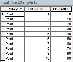
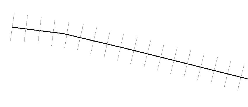
This builds on from the previous post creating points at specified distances along a line. Here, we create perpendicular chainage ticks that traverse the main line.
from osgeo import ogr
from shapely.geometry import MultiLineString, LineString, Point
from shapely import wkt
import sys, math

## http://wikicode.wikidot.com/get-angle-of-line-between-two-points
## angle between two points
def getAngle(pt1, pt2):
    x_diff = pt2.x - pt1.x
    y_diff = pt2.y - pt1.y
    return math.degrees(math.atan2(y_diff, x_diff))

## start and end points of chainage tick
## get the first end point of a tick
def getPoint1(pt, bearing, dist):
    angle = bearing + 90
    bearing = math.radians(angle)
    x = pt.x + dist * math.cos(bearing)
    y = pt.y + dist * math.sin(bearing)
    return Point(x, y)
## get the second end point of a tick
def getPoint2(pt, bearing, dist):
    bearing = math.radians(bearing)
    x = pt.x + dist * math.cos(bearing)
    y = pt.y + dist * math.sin(bearing)
    return Point(x, y)

## set the driver for the data
driver = ogr.GetDriverByName("FileGDB")
## path to the FileGDB
gdb = r"C:\Users\******\Documents\ArcGIS\Default.gdb"
## open the GDB in write mode (1)
ds = driver.Open(gdb, 1)

## linear feature class
input_lyr_name = "input_line"

## distance between each points
distance = 10
## the length of each tick
tick_length = 20

## output tick line fc name
output_lns = "{0}_{1}m_lines".format(input_lyr_name, distance)

## list to hold all the point coords
list_points = []

## reference the layer using the layers name
if input_lyr_name in [ds.GetLayerByIndex(lyr_name).GetName() for lyr_name in range(ds.GetLayerCount())]:
    lyr = ds.GetLayerByName(input_lyr_name)
    print "{0} found in {1}".format(input_lyr_name, gdb)

## if the output already exists then delete it
if output_lns in [ds.GetLayerByIndex(lyr_name).GetName() for lyr_name in range(ds.GetLayerCount())]:
    ds.DeleteLayer(output_lns)
    print "Deleting: {0}".format(output_lns)

## create a new line layer with the same spatial ref as lyr
out_ln_lyr = ds.CreateLayer(output_lns, lyr.GetSpatialRef(), ogr.wkbLineString)

## distance/chainage attribute
chainage_fld = ogr.FieldDefn("CHAINAGE", ogr.OFTReal)
out_ln_lyr.CreateField(chainage_fld)
## check the geometry is a line
first_feat = lyr.GetFeature(1)

## accessing linear feature classes using FileGDB driver always returns a MultiLinestring
if first_feat.geometry().GetGeometryName() in ["LINESTRING", "MULTILINESTRING"]:
    for ln in lyr:
        ## list to hold all the point coords
        list_points = []
        ## set the current distance to place the point
        current_dist = distance
        ## get the geometry of the line as wkt
        line_geom = ln.geometry().ExportToWkt()
        ## make shapely MultiLineString object
        shapely_line = MultiLineString(wkt.loads(line_geom))
        ## get the total length of the line
        line_length = shapely_line.length
        ## append the starting coordinate to the list
        list_points.append(Point(list(shapely_line[0].coords)[0]))
        ## https://nathanw.net/2012/08/05/generating-chainage-distance-nodes-in-qgis/
        ## while the current cumulative distance is less than the total length of the line
        while current_dist < line_length:
            ## use interpolate and increase the current distance
            list_points.append(shapely_line.interpolate(current_dist))
            current_dist += distance
        ## append end coordinate to the list
        list_points.append(Point(list(shapely_line[0].coords)[-1]))

        ## add lines to the layer
        ## this can probably be cleaned up better
        ## but it works and is fast!
        for num, pt in enumerate(list_points, 1):
            ## start chainage 0
            if num == 1:
                angle = getAngle(pt, list_points[num])
                line_end_1 = getPoint1(pt, angle, tick_length/2)
                angle = getAngle(line_end_1, pt)
                line_end_2 = getPoint2(line_end_1, angle, tick_length)
                tick = LineString([(line_end_1.x, line_end_1.y), (line_end_2.x, line_end_2.y)])
                feat_dfn_ln = out_ln_lyr.GetLayerDefn()
                feat_ln = ogr.Feature(feat_dfn_ln)
                feat_ln.SetGeometry(ogr.CreateGeometryFromWkt(tick.wkt))
                feat_ln.SetField("CHAINAGE", 0)
                out_ln_lyr.CreateFeature(feat_ln)

            ## everything in between
            if num < len(list_points) - 1:
                angle = getAngle(pt, list_points[num])
                line_end_1 = getPoint1(list_points[num], angle, tick_length/2)
                angle = getAngle(line_end_1, list_points[num])
                line_end_2 = getPoint2(line_end_1, angle, tick_length)
                tick = LineString([(line_end_1.x, line_end_1.y), (line_end_2.x, line_end_2.y)])
                feat_dfn_ln = out_ln_lyr.GetLayerDefn()
                feat_ln = ogr.Feature(feat_dfn_ln)
                feat_ln.SetGeometry(ogr.CreateGeometryFromWkt(tick.wkt))
                feat_ln.SetField("CHAINAGE", distance * num)
                out_ln_lyr.CreateFeature(feat_ln)

            ## end chainage
            if num == len(list_points):
                angle = getAngle(list_points[num - 2], pt)
                line_end_1 = getPoint1(pt, angle, tick_length/2)
                angle = getAngle(line_end_1, pt)
                line_end_2 = getPoint2(line_end_1, angle, tick_length)
                tick = LineString([(line_end_1.x, line_end_1.y), (line_end_2.x, line_end_2.y)])
                feat_dfn_ln = out_ln_lyr.GetLayerDefn()
                feat_ln = ogr.Feature(feat_dfn_ln)
                feat_ln.SetGeometry(ogr.CreateGeometryFromWkt(tick.wkt))
                feat_ln.SetField("CHAINAGE", int(line_length))
                out_ln_lyr.CreateFeature(feat_ln)

del ds
The output is a linear feature class containing chainage ticks and distance attribute.

Please leave comments if this can be improved or if you found it useful.